


Cape Verde Alert: Tropical Disturbance Could Bring Torrential Rain and Wind Gusts
A low-pressure system near Cape Verde could develop into the fifth named storm of the 2025 Atlantic season. With winds of up to 56 km/h and a forecast of heavy, gusty rain in the archipelago, the NHC estimates an 80% probability of formation in the next seven days. If named, it will be called Erin.
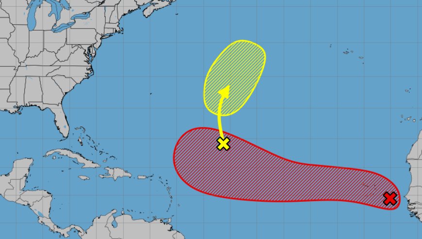
The US National Hurricane Center (NHC) reported on Sunday morning that a low-pressure system, located between Cape Verde and the West African coast, is highly likely to become the fifth named storm of the 2025 Atlantic hurricane season.
According to meteorologists, the well-defined system could develop into a depression or tropical storm by Monday. If this doesn't happen, the environmental conditions forecast for the rest of the week favor its strengthening.
On Sunday morning, the disturbance recorded maximum winds of 56 km/h (35 mph) and was moving west-northwest at a speed of between 24 and 32 km/h (15 to 20 mph). Strong winds and heavy rain are forecast for Cape Verde until Monday. The NHC assigns a 40% probability of formation in the next two days and 80% next week.
If it gains strength and is named, the storm will be called Erin. So far, the 2025 season has seen four tropical storms: Andrea, Barry, Chantal and Dexter, but no hurricanes.
Another low pressure system was also being monitored in the central tropical Atlantic, with slow development due to the presence of dry air. The probability of this second system forming is 20% over the next seven days.